Shaded geography as described here is the layout of the seas and continents on the surface of this basically spherical
planet.
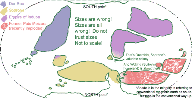
Rough working map: (NOTE: continent sizes and shapes and possibly positions are ALL liable to change)
World powers
Northern hemisphere
Southern hemisphere
Continents and countries on Shade
-
- 1. Terrimoire
-
-
- 1.1. Species and climate
-
- 1.2. Woking
-
- 1.3. Montuone
-
- 1.4. Region L
-
- 1.5. Soprone
-
2. Dor Roc-
1. Terrimoire
Terrimoire (pron. "terri muar"; commonly shortened to Timoire pron. "timuar") is the name given to part of the main landmass in the northern hemisphere. (Terrimoire is a name in the language of the former
Pais Meizurs.)
1.1. Species and climate
Roughly, very roughly, greens and browns on the Soprone end (higher percentage voks south and sroll north), red and gold in the former P.M. (south especially feraisai, generally much smaller density of ferais than others wherever you look). Very wooded overall. Climate and plant life from mediplanetary in south to fairly Norwegian in north, and a small land bridge connects the continent to the north pole.
For animals, see Fauna of Shade, also Animals in Terrimoirine folk stories
I have no idea about rivers and lakes, except an inland sea close by Montuone.
- landlocked country
- former 'protectorate', or 'you're a bit too far away for us to control', of Pais Meizurs (on the edge of their reach at height of power)
- faleighs, a few ferais
- bimonarchy (two kings)
- Suitov is from here (so is Siri)
- surrounded by a honking huge mountain range:
- "mont wohn"
- protectorate of Soprone
- srollen and voksin
- not voksin republic, run by council of leaders elected from Families
- manufacture, skilled labour, trading links?
- stone quarries
- sparse forests
- Wilmer and Johan Stuck are from here
1.4. Region L
- up north around the land bridge to the pole
- reaching up almost to polar treeline
- srollen almost exclusively, some borean faleigh
- poor, rough, lot of wild/useless land
- lots of foresty bits
- Lotsi is from here
1.5. Soprone
- "sopp roan"
- empire, in the sense that it controls land -- no emperor
- consists of the Soprone 'heartlands' in Timoire and territories and protectorates around the globe
- Soprone heartlands are large area, getting to mediplanetary climate in south
- mediplanetary plant life + cultivated vineyards etc
- voksin republic (they INVENTED voksin republics)
- high percentage voks, many sroll, good representation of faleigh and ferais too.
- Mutt's Nico is from here
- a continent to itself
- rocca, isolated ferais (or voks? which did rocca tolerate?) places in south
- note - this is the only region with native rocca - ALL rocca are from here
- generally nomadic horse culture
- largely uncultivated, grasslands, poor soil
- no settlements. You do not mess with the huge mounted archers
- no trade
- (suspect there will be raiding parties for their horses once the Twine Wars kick off)
- luckily for everyone else, huge mounted archers do not have sea travel
![[Home]](/styles/knot.jpg)