Shaded geography as described here is the layout of the seas and continents on the surface of this basically spherical
planet.
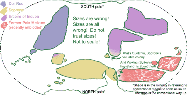
Rough working map: (NOTE: continent sizes and shapes and possibly positions are ALL liable to change)
World powers
Northern hemisphere
Southern hemisphere
Terrimoire
Terrimoire, on a world map, is the eastern 'continent'/region in the northern hemisphere. (I haven't even begun deciding on the plate tectonics). T'm is a
feraisai name.
Roughly, very roughly, greens and browns in west (higher percentage voks southwest and sroll northwest), red and gold in east (southeast especially feraisai, generally less mixing of ferais with other species). Climate and plant life from mediplanetary in south to fairly Norwegian in northwest. Very wooded overall.
see also Animals in Terrimoirine folk stories
We'll start with the place where Ice comes from, which is eastern Terrimoire
WEST of Woking
- mountain range, roughly N-S direction
WEST of mountain range
- Montuone country ("mont woan" or "mont wonn", meh?)
- srollen and voksin
- not voksin republic, run by council of leaders elected from Families
- manufacture, skilled labour, trading links?
- stone quarries
- sparse forests
- Wilmer and Johan Stuck are from here
NORTH of Montuone
- Region L (for Lotsi, no name yet)
- reaching up almost to polar treeline
- srollen
- poor, rough, lot of wild/useless land
- lots of foresty bits
- Lotsi is from here
SOUTHEAST of Montuone
- Soprone country ("sopp roan")
- voksin republic
- high percentage voks
- getting to mediplanetary climate
- mediplanetary plant life + cultivated vineyards etc
- Mutt's Nico is from here
WEST of Montuone (some distance west? likely natural barrier, probably sea)
- Region R (for rocca, no name yet)
- rocca, isolated ferais places in south(?)
- note - this is the only region with native rocca - ALL rocca are from here
- rocca generally nomadic horse culture
- largely uncultivated, grasslands, poor soil
- rocca keep everyone else out. You do not mess with the huge mounted archers
SOUTH of Region R
I have no idea about seas, rivers and lakes. All above-mentioned regions connected by land?
![[Home]](/styles/knot.jpg)